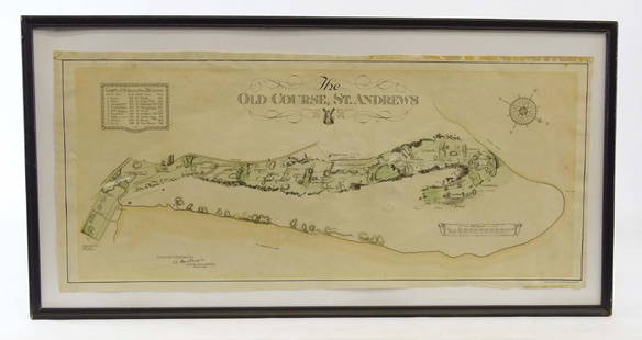
Sold2019Scotland Early Golf MapOld Course St. Andrews Map. Surveyed by A. MacKenize Architect, 1924. McCorquodale & Co., Glasgow, C. 1924. Sight 10 3/4" x 24 1/2".See Sold Price
Sold2022Plan of St. Andrews Links Booklet with MapEarly booklet with folding map Plan of Golf Courses, showing Old, New and Jubilee Courses. Robert Forgan & Son, Scotland ad inside front cover. Early manuscript note verso. Rare book pocket map cartogSee Sold Price
Sold2016JOHN MELISH (SCOTLAND/AMERICAN 1771-1822), EARLY ANDJOHN MELISH (SCOTLAND/AMERICAN 1771-1822), EARLY AND RARE MAP OF THE UNITED STATES OF AMERICA, C.1813. ENTERED AS THE ACT DIRECTS AND PUBLISHED BY JOHN MELISH, PHILADELPHIA, JUNE 1813. SIGHT 13 X 17 1See Sold Price
Sold2017Early Hand Colored Map of ScotlandFramed hand colored map of Scotland; 23in. X 19in.See Sold Price
Sold2021Masters Golf Map Signed by SarazenGene Sarazen (1902-1999) autographed 1967 Augusta National Golf Club map (over 15th hole). Framed with photo of Sarazen. Plus framed English engraving of early golfing. Largest frame 31" x 24".See Sold Price
Sold2024Ptolemy & Magini, pub. 1620 - Map of the British Isles (England, Scotland, Ireland) / Verso: Map ofThis early map engraving is from Claudius Ptolemaeus (Ptolemy) and Giovanni Antonio Magini's Geografia cio? Descrittione Universale della Terra Partita in due volumni, Nel Primo de' quali si contengonSee Sold Price
Sold2023Two early maps in America and North America.Two early hand colored maps of New York State & North America including: The first, New Caldonia when it was still a colony of Scotland, dated 1699 - published by M. Moll - very good condition; and thSee Sold Price
Sold2019SCOTLAND general map showing castles & kirks. Railways.TITLE/CONTENT OF MAP: 'SCOTLAND' The map shows some early railways The top image on the right hand side shows the entire map. To view a close up of the map showing the level of printed detail, pleaseSee Sold Price
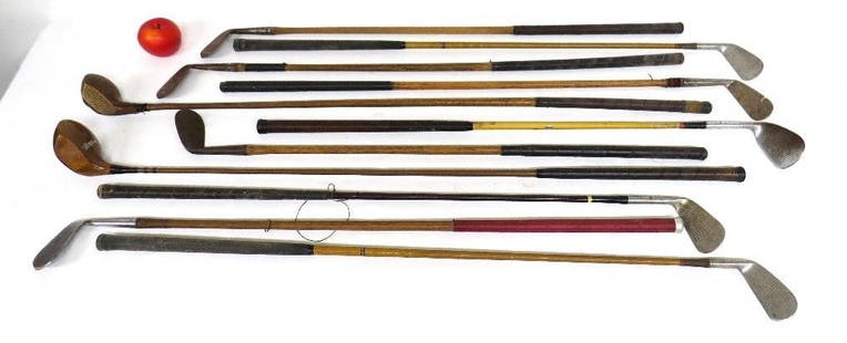
Sold202311 Antique Hickory Shaft & Wood Grain Golf Clubs/DriversLot of early golf clubs, some with hickory shafts, others metal woodgrained, MacGregor, Spalding, Cruikshank, Scotland etc. Some oxidation in spots, overall decent group nice decorator lotSee Sold Price
Sold2017Edinburgh, Scotland 1940's Map/Bus Routes/Golf CourseEdinburgh, Scotland 1940's Map/ Bus Routes/ Golf Courses/ Points of Interest, Travel Guide. the Item Is in Good Condition. Please note that this lot has a confidential reserve. When you leave a bid inSee Sold Price
Sold2022Four early 20thC bound road maps of Scotland comprising North, North Central, South and SouthFour early 20thC bound road maps of Scotland comprising North, North Central, South and South Central. Contained within a leather carrying case stamped SCOTLAND with retailers stamp within for The MapSee Sold Price
Sold2021Antique Engraving of Saint Andrews Golf CourseEarly antique engraving of Saint Andrews Golf course in Scotland. Titled "The Golfers", engraved by Chas E. Waffstaffe. Frame 40"x29".See Sold Price
Sold2023Early Map of Tennessee, Daniel Smith, 1795A MAP OF THE TENNASSEE [sic] GOVERNMENT FORMERLY PART OF NORTH CAROLINA TAKEN CHIEFLY FROM SURVEYS BY GENL. D. SMITH & OTHERS, drawn by Daniel Smith, engraved by Joseph T. Scott, for "General Atlas FoSee Sold Price
Sold2017America, Rare Early Map of the Americas"America", Rare Early Map of the Americas by Jodocus Hondius (Flemish/Dutch, 1563-1612) for a French edition of Mercator's Atlas, North and South America, hand-colored copper engraved map, published ASee Sold Price
Sold2022EARLY MAP "AMERICA"John Speede 1626, Thomas Bassett / Richard Chillwell, Abraham Goos; "The Description of America", hand colored, center fold, slight foxing, framed size 19" x 23 1/2", G-G+See Sold Price
Sold2023Album of Early Maps and Ephemera Related to CubaA collectors album of maps and prints related to Cuba. There are total of 70 pieces, from the 16th to the 20th centuries. Highlights include works by Theodor de Bry, a 1561 map of Cuba by Ruscelli, aSee Sold Price
Sold2022EARLY MAP OF BRITAINJohn Speede / Thomas Basett, bookplate "Sanon Heptarchy" on reverse, hand colored, center fold, slight toning, framed size 19" x 23 1/2", G-G+See Sold Price
Sold2022LARGE EARLY MAP"The Washington Map of The United States", 1861, approximate size 69 1/2" x 69", with early thin linen backingSee Sold Price
Sold2016Early Map: "A New Map Of North America...."Early map: "A New Map Of North America Showing its Principal Divisions....Dedicated To His Highness William Duke Of Gloucester...". Dated 1573. Sight 15" x 19 1/2".See Sold Price
Sold2022EARLY MAP OF AFRICA"Africae" "Newly Done into English John Speede / G. Humble 1626" engraved by Abraham Goos, bookplate "The Description of Africa" on reverse, hand colored; minor tear, foxing, toning, tape marks; frameSee Sold Price
Sold2021Early Map of Bexar County, TXEarly map of Bexar County, TX, showing original land grants, framed frame: 30"h x 34"w Provenance: A San Antonio, TX Collection We happily provide seamless shipping services on everything we sell.See Sold Price
Sold2023Extremely scarce and early map of Ohio, M. Carey 1814One of the most influential early maps of Ohio and the first large format map of Ohio to appear in an atlas. This 1816 example is the identical map that appeared in Carey’s 1814 General Atlas.See Sold Price
Sold2016Early Map of The Michigan Territory by CareyThe Upper Territories of the United States, 1814. Matthew Carey (1760-1839). Engraved map with original hand color in outline. Philadelphia, 1814. 22 x 17 1/4 inches sheet. The map reflects a very earSee Sold Price
Sold2015Early map of Galway dated 1610, "Performet by JohnEarly map of Galway dated 1610, "Performet by John Speede," 15 by 20 inches, framed.See Sold Price
2 hrs LeftJasper52Southern Ayrshire. Turnberry Maybole Girvan Ballantrae Cumnock THOMSON 1832 map$360
2 hrs LeftJasper52Northern Ayrshire. Troon Irvine Ardrossan Kilmarnock Prestwick. THOMSON 1832 map$360
BonhamsCAMDEN (WILIAM) Britannia; or, a Chorographical Description of the Flourishing Kingdoms of Engla...£50(3 bids)
BonhamsIRELAND - IRISH BIBLE [New Testament] Tiomna nuadh ar dtighearna agus slanaightheora iosa criosd...£360
2 hrs LeftJasper52Italian Lakes by Swiss Federal Office of Topography. 105x70cm. Folding map 1874$420


![Early Map of Tennessee, Daniel Smith, 1795: A MAP OF THE TENNASSEE [sic] GOVERNMENT FORMERLY PART OF NORTH CAROLINA TAKEN CHIEFLY FROM SURVEYS BY GENL. D. SMITH & OTHERS, drawn by Daniel Smith, engraved by Joseph T. Scott, for "General Atlas Fo](https://p1.liveauctioneers.com/525/272425/142901899_1_x.jpg?height=310&quality=70&version=1671337478)


![IRELAND - IRISH BIBLE [New Testament] Tiomna nuadh ar dtighearna agus slanaightheora iosa criosd... (1 of 2)](https://p1.liveauctioneers.com/1043/319451/178359120_1_x.jpg?height=282&quality=70&version=1717776916)


