Sold20211800 Weld Map of Northern United States and Great LakesTitle: 1800 Weld Map of Northern United States and Great Lakes -- Partie des Etats-Unis de L'Amerique Septentrionale Cartographer: I Weld Year / Place: 1800, Paris Map Dimension (in.): 16.1 X !8.2 in.See Sold Price
Sold20231950s Native American Birch Bark Canoe Model w/ DollNative American, Northern United States, Great Lakes region, Iroquois / Seneca / Ojibwe, ca. 1950s CE. A hand-made vintage canoe model made from birchbark over a cedar / spruce wood frame with black pSee Sold Price
Sold2023Early Winnebago / Ojibwe Beaded Leather PouchNative American / First Nations, Northern United States / Canada, Great Lakes Region & Midwest, Winnebago / Ojibwe, ca. early 20th century CE. A hide bag with beadwork across both sides, the front panSee Sold Price
Sold2018RAILROADIANA LOT 1939-1957, BOOKS, MAP, BROCHURESThis lot includes: Map of United States/Great Northern Railway, framed photo of freight train derailment in 1947 at Jennings, Montana, 1957 The Railway Mail Story, 1939 Consolidated Code of TransportaSee Sold Price
Sold2018Thomson: Antique Map Northeastern United States, 1817Northern Provinces of the United States The beautifully detailed and colored northern United States map from Thomson's New General Atlas, with a lovely inset view of "the Great Falls of Niagara.'" CarSee Sold Price
Sold2021(MICHIGAN.) Maps and Report . . . for Ascertaining the(MICHIGAN.) Maps and Report . . . for Ascertaining the Northern and Northwestern Boundary between the United States and Great Britain. 8 maps with hand-colored border in blue and red. 2 text leaves. FSee Sold Price
Sold20211844 map of the U. S., Canada & MexicoGreat map of the United States showing Texas in a very large configuration, otherwise known as the “Stovepipe” shape, with its northern border going all the way into what would become the state ofSee Sold Price
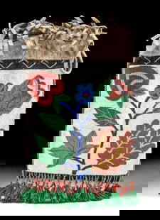
Sold20241920s Native American Chippewa Beaded Leather Bag**Originally Listed At $300** First Nations / Native American, Midwestern United States / Canada, Great Lakes Region & Midwest, Chippewa / Ojibwe, ca. 1920s to 1930s CE. A fringed hide drawstring bagSee Sold Price
Sold2018United States Cleveland Centennial/Great LakesUnited States Cleveland Centennial/Great Lakes Exposition Commemorative Half Dollar: 1936.See Sold Price
Sold2020"Northern provinces of the United States". THOMSON.TITLE/CONTENT OF MAP: 'Northern provinces of the United States' The map shows the "District of Maine", prior to its accession to the Union as the state of Maine in 1820. The top image on the right hanSee Sold Price
Sold2023Northern provinces of the United States. THOMSON. District of Main[e] 1817 mapTITLE/CONTENT OF MAP: 'Northern provinces of the United States' The map shows the "District of Maine", prior to its accession to the Union as the state of Maine in 1820. Some Native American Indian viSee Sold Price
Sold2019Northern provinces of the United States. THOMSON.TITLE/CONTENT OF MAP: 'Northern provinces of the United States' The map shows the "District of Maine", prior to its accession to the Union as the state of Maine in 1820. Some Native American Indian viSee Sold Price
Sold2022Canada and Northern United States 1878 MapSize: 18 X 13 inches approx. Unframed. Printed 1878. Centerfold as issued.See Sold Price
Sold2023[MAPS & ATLASES]. COLTON, Joseph Hutchins. Colton's Map of the United States of America, the[MAPS & ATLASES]. COLTON, Joseph Hutchins (1800-1893). Colton's Map of the United States of America, the British Provinces, Mexico and the West Indies. Showing the Country from the Atlantic to theSee Sold Price
Sold2022Vintage map of Wisconsin & Michigan, 1865Johnson and Ward’s dynamic layout showing both of these Great Lakes states. The map includes parts of four of the five Great Lakes. Railroads, roads, coastal features, rivers, lakes, mines, IndiSee Sold Price
Sold2019Map of the Northern Parts of the United States OfTitle: Map of the Northern Parts of the United States Of America by Abraham Bradley, Jr. Corrected by The Author. Prublication Date: 1797 Cartographer: BRADLEY, ABRAHAM, JR. | JEDIDIAH MORSE PublisherSee Sold Price
Sold2021Map of the Northern Parts of the United States OfPublication Date: 1797 Title: Map of the Northern Parts of the United States Of America Cartographer: BRADLEY, ABRAHAM, JR. AND JEDIDIAH MORSE Publisher: THOMAS & ANDREWS, Height: 8.25 Width: 15.5 "bySee Sold Price
Sold2019Map of the Northern Parts of the United States OfTitle: Map of the Northern Parts of the United States Of America Publication Date: 1802 Cartographer: BRADLEY, ABRAHAM, JR. for JEDIDIAH MORSE Publisher: THOMAS & ANDREWS, Size: 8.25Height - 15.5WidthSee Sold Price
Sold2017Mollo: Antique Map of United States, 1800Map: Vereinigte Staaten in Nord America Cartographer: T. Mollo Place & Date: Vienna / 1800 (?) Size: 17 1/2" x 12 1/2" Condition: b&w; states and territories outlined in color; overall age toning; somSee Sold Price
Sold2023Great Lakes SashGreat Lakes Sash. Northeastern United States. 19th century. L 61" W 9". Provenance: Massachusetts estate. Collected mid 20th century. Condition: Excellent condition. Copy and paste link for high-res iSee Sold Price
Sold2017Map of United States, Texas & Oklahoma as 1 TerritoryEarly map of the United States with Texas and Oklahoma as one territory. W. R. Chambers. Circa 1850 map of the United States extends into the Great Plains here split up between Nebraska and Kanzas TerSee Sold Price
Sold2017Burgess: Antique Map of the United States & Canada 1853Map of the United States and Canada, Burgess 1853. Great map of the U. S. during the transitional period of the American West. Most of the western lands are shown as large territories: Minnesota, NebrSee Sold Price
Sold2022Scarce 1844 U. S. map w/large Texas, western territoriesOne of the more interesting and elusive school maps of the United States at a time of great territorial expansion. This 1844 double-page Olney school geography map shows the Republic of Texas in one oSee Sold Price
Sold20204 Pere Marquette Railway Cast RoundsPere Marquette Railway (Reporting mark PM operated in the Great Lakes Region in the United States & Southern parts of Ontario), R-1PM960, R-2PM961, R-3PM962, R-4PM963.See Sold Price
Jun 01Black Hills Curio CompanyGreat lakes c1910-1930 Native American Pictorial Deer Head & Geometric Design Bag - Loom Beaded$100(1 bid)
1 day LeftKey Date CoinsApril 4, 1961 New York Central Railroad Company 100 Shares Stock Certificate Grades$50
Jun 01Ripley AuctionsGianni Cilfone, American / Italian (1908 - 1992), lake landscape with figures, oil on board, 11$100(1 bid)
1 hr LeftThomaston Place Auction GalleriesFRAMED HARPERS MAGAZINE DOUBLE-PAGE FROM HISTORY OF THE GREAT REBELLION$100(1 bid)


![Northern provinces of the United States. THOMSON. District of Main[e] 1817 map: TITLE/CONTENT OF MAP: 'Northern provinces of the United States' The map shows the "District of Maine", prior to its accession to the Union as the state of Maine in 1820. Some Native American Indian vi](https://p1.liveauctioneers.com/5584/309982/165835410_1_x.jpg?height=310&quality=70&version=1700599538)


![[MAPS & ATLASES]. COLTON, Joseph Hutchins. Colton's Map of the United States of America, the: [MAPS & ATLASES]. COLTON, Joseph Hutchins (1800-1893). Colton's Map of the United States of America, the British Provinces, Mexico and the West Indies. Showing the Country from the Atlantic to the](https://p1.liveauctioneers.com/197/305583/163286506_1_x.jpg?height=310&quality=70&version=1697143109)


