Sold2023Northern Ireland, Two Antique Maps, Sir Charles CooteDescription: Two antique maps of Northern Ireland from the 1804 Statistical Survey by Sir Charles Coote, including a of Lough Neagh and County Adjacent, and a map of the county of Armagh taken from RoSee Sold Price
Sold2022John SPEED: Two Antique Maps of IrelandTwo framed antique maps of Ireland by John Speed, a well known English cartographers circa 17th century. [Maps: 15" H x 20" W; Frames: 24" H x 28 1/2" W].See Sold Price
Sold2017Prinald / Coote: Antique Map of Ireland, 1759Title/Content of Map: 1759 Map of Ireland -- A New map of Ireland from the Best Observations Date Printed: 1759 c., London Cartographer: Prinald / J Coote Size: 10.8 x 7.3 in. Condition: Very Good. UnSee Sold Price
Sold2023Collection of David Birney: Two Antique Mapseach: etching; the first: "Ireland from the Best Authorities", frame: 13 1/2 x 14 in. (34.3 x 35.6 cm.); the second: "Lutetia vulgo Paris Anno 1575" (reproduction), frame 18 x 24 in. (45.7 x 61 cm.);See Sold Price
Sold2018Two Antique MapsMap of Northern Hemisphere: Carte Des Nouvelles Decouvertes Au Nord De La Mer Du Sud, 18" x 24 1/2" (sight) Francois Santini, Venice and Map Of North America: Nuove Scoperte De' Russi, 12" x 15 3/4" (See Sold Price
Sold2021Rapkin, John 1858 Antique Map. Northern IndiaSteel Engraved Map Published 1858, London for "The History of the Indian Mutiny..." by Charles Ball. Centre fold as published. Drawn & Engraved by John Rapkin. Paper Size: 14 x 11 inch (36 x 28cm) GooSee Sold Price
Sold2021Antique French map of Northern America engravingAntique French map of Northern America engraving Charles V. Monin (18..-1880). Charles V. Monin (18..-1880) was a French cartographer and publisher, three important atlases and several independent worSee Sold Price
Sold2018Ireland. [in Counties]Reserve Reduced! Title: Ireland. [in Counties] Publication Date: 1847 Cartographer: Sidney Hall Publisher: Adam & Charles Black Size: 19X15.25 Larger of two maps of Ireland showing highways, topographSee Sold Price
Sold2018Ireland 1802-C1880 Lot of 7 Antique MapsLot of 7 Antique Maps - One Copper engraved, the others Lithographed, including one duplicate. Examples by National Encyclopedia, Arrowsmith/Lowry, Charles Knight, Hughes and others. Paper Size: Up toSee Sold Price
Sold2023TWO 1835 CONSTELLATION MAPS2 framed antique constellation hand colored maps circa 1835 by DFJ Huntington of Hartford CT, printed by WG Evans of NY - Plate V and Plate VI Northern Circumpolar. Each 14.5 x 13.5 image, framed 19 xSee Sold Price
Sold2018A SONG DYNASTY CIZHOU SGRAFFIATO VASE AND STANDA Northern Song Dynasty Cizhou Sgraffiato Vase and Stand. Dimensions: 12 x 5 1/4 in. Provenance: From the collection of Charles George(1898-1983). Manager of Sir Victor Sassoon's Empire in China, Mr CSee Sold Price
Sold2021A SONG DYNASTY CIZHOU SGRAFFIATO VASE AND STANDA Northern Song Dynasty Cizhou Sgraffiato Vase and Stand. Dimensions: 12 x 5 1/4 in. Provenance: From the collection of Charles George(1898-1983). Manager of Sir Victor Sassoon's Empire in China, Mr CSee Sold Price
2019A SONG DYNASTY CIZHOU SGRAFFIATO VASE AND STANDA Northern Song Dynasty Cizhou Sgraffiato Vase and Stand. Dimensions: 12 x 5 1/4 in. Provenance: From the collection of Charles George(1898-1983). Manager of Sir Victor Sassoon's Empire in China, Mr CSee Sold Price
Sold2023TWO ANTIQUE MAPS OF CHINA.Two antique maps of China, including Chinae by Abraham Ortelius, 1595, image 14.25” x 18.25”, with map of Eastern Asia, Le table de la region orientale, image 10” x 13.5”.See Sold Price
2021GREAT NORTHERN’S 2 GREAT TRAINS SYSTEM MAP.Huge dramatic reverse glass advertising Great Northern's two great trains, Empire Builder and Western Star. In script just below Great Northern logo it states "Steamliners twice a day, each way, betweSee Sold Price
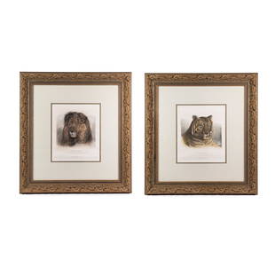
Sold2023(2) J. F. Lewis Head of Lion and Tiger Colored EngravingsA set of two (2) antique engravings by John Frederick Lewis (English, 1805-1876) titled 'Head of a Lion' the Drawing in the Possession of Sir J.E. Swinburne, Bart, published by W.B.Cooke 9. Soho SquarSee Sold Price
Sold2023Antique Framed Wayfarer's Map of New York 1939Antique Framed Wayfarer's Map of New York 1939. Framed. Signed by Charles D. Graves, possibly the map maker. Copyrighted 1939, Herbert C. Wyman, Pleasantville, NY. Wayfarer's Maps.See Sold Price
Sold2022John Speed, Two Vintage Copper Engraved MapsJOHN SPEED (British, 1552-1629), Invasions of England & Ireland with al their Civill Wars Since the Conquest, 1676, and Britain as it was Divided, two copper engraved maps with hand-coloring, image (eSee Sold Price
Sold2022(COLONIAL NORTH AMERICA.) John Senex, Charles Price, and John Maxwell. North America.(COLONIAL NORTH AMERICA.) John Senex, Charles Price, and John Maxwell. North America. Large engraved map of North America on two sheets of laid paper joined. 39x26¾ inches overall, wide margins;See Sold Price
Sold2021A VERY LARGE BLUE AND WHITE VASE YONGZHENG PERIODA VERY LARGE BLUE AND WHITE VASE YONGZHENG PERIOD. Dimensions: 23 1/2 x 15 in. Provenance: From the collection of Charles George(1898-1983). Manager of Sir Victor Sassoon's Empire in China, Mr CharlesSee Sold Price
Sold2018A QING DYNASTY WHITE JADE GUANYIN BOULDER & STANDA Qing Dynasty White Jade Guanyin Boulder and Stand. Dimensions: 8 3/4 x 4 3/4 x 2 in. Provenance: From the collection of Charles George(1898-1983). Manager of Sir Victor Sassoon's Empire in China, MrSee Sold Price
Sold2018A QING DYNASTY VASE QIANLONG MARK AND PERIODA Qing Dynasty Famille Rose Vase Qianlong Mark and Period. Dimensions: 8 1/4 x 4 1/2 in. Provenance: From the collection of Charles George(1898-1983). Manager of Sir Victor Sassoon's Empire in China,See Sold Price
Sold2021A LARGE BLUE WHITE VASE QIANLONG MARK AND PERIODA LARGE BLUE AND WHITE VASE QIANLONG MARK AND PERIOD. Dimensions: 18 1/4 x 12 1/4 in. Provenance: From the collection of Charles George(1898-1983). Manager of Sir Victor Sassoon's Empire in China, MrSee Sold Price
Sold2018A MING DYNASTY BLUE AND WHITE EIGHT IMMORTALS JARA Ming Dynasty Blue and White Eight Immortals Jar. Dimensions: 13 3/4 x 13 1/2 in. Provenance: From the collection of Charles George(1898-1983). Manager of Sir Victor Sassoon's Empire in China, Mr ChaSee Sold Price
7 days LeftJasper52Stratford-upon-Avon & William Shakespeare's life. Kerry Lee pictorial map c1965$440
7 days LeftJasper52IRELAND on 2 sheets conjoined 62x50 cm. Round towers Cloigthithe. SDUK 1844 map$320
BonhamsIRELAND - MANUSCRIPT PEDIGREES Two Manuscript pedigrees of the Bolton family of Mount Bolton, Wa...£550
7 days LeftJasper52LONDON UNDERGROUND tube map plan diagram. Northern Heights SCHLEGER/ZERO #3 1939$260
7 days LeftJasper52LONDON UNDERGROUND tube map diagram plan. Northern Heights SCHLEGER/ZERO #2 1939$260
7 days LeftJasper52IRELAND on 2 sheets conjoined 62x50 cm. Round towers Cloigthithe. SDUK 1844 map$320
7 days LeftJasper52The United Parishes of St. Giles in the Fields & St. George, Bloomsbury 1828 map$550
BonhamsDICKENS (CHARLES) Autograph letter signed ('Charles Dickens'), to C.F. Smith ('Dear Sir'), Tavis...£750
6 days LeftJasper521896 STANFORD'S COMPEDIUM of GEOGRAPHY & TRAVEL ASIA 2 VOLS. antique ILLUSTRATED$220
6 days LeftJasper521902 ACROSS COVETED LANDS JOURNEY to CALCUTTA INDIA 2 VOLS. antique ILLUSTRATED$240
2 days LeftTrillium Antique Prints & Rare BooksCluver - 3 Engravings of Compass Rose & Scientific Charts & Diagrams$75
BonhamsIRELAND - ULSTER COVENANT, U.V.F., CARSON AND CRAIG Album relating to the Ulster Covenant, James...£10


![John SPEED: Two Antique Maps of Ireland: Two framed antique maps of Ireland by John Speed, a well known English cartographers circa 17th century. [Maps: 15" H x 20" W; Frames: 24" H x 28 1/2" W].](https://p1.liveauctioneers.com/1221/264089/138965458_1_x.jpg?height=310&quality=70&version=1667576821)


![Ireland. [in Counties]: Reserve Reduced! Title: Ireland. [in Counties] Publication Date: 1847 Cartographer: Sidney Hall Publisher: Adam & Charles Black Size: 19X15.25 Larger of two maps of Ireland showing highways, topograph](https://p1.liveauctioneers.com/5584/130079/66157224_1_x.jpg?height=310&quality=70&version=1540941379)


![Pearce, Thomas [attributed to] (1 of 1)](https://p1.liveauctioneers.com/94/330664/178342289_1_x.jpg?height=282&quality=70&version=1716466933)

