


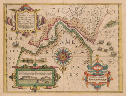
STRAITS of MAGELLAN & TIERRA DEL FUEGO called
Similar Sale History
View More Items in Maps & Atlases
![Extremité Meridionale de l'Amérique Tierra del Fuego Magellan Str BONNE 1788 map: [Cook 2e Voyage] Extremité Meridionale de l'Amérique // Partie Est de la Terre de Feu, le Détroit de Le Maire et partie ouest de la terre des Etats // Canal de Noël // Suite de la Côte](https://p1.liveauctioneers.com/5584/294908/156576945_1_x.jpg?height=310&quality=70&version=1688565030)


Related Maps & Atlases


![Carte de la Nouvelle Zéelande. New Zealand. Cook Strait. Thames. BONNE 1788 map: TITLE/CONTENT OF MAP: [Cook 3e Voyage] Carte de la Nouvelle Zéelande // Carte du Détroit de Cook // Baye des Isles // Baye de Tolaga // Rivière de la Tamise et de la Baye de Mercure [Co](https://p1.liveauctioneers.com/5584/332390/179262927_1_x.jpg?height=310&quality=70&version=1717528223)
![Océanique. Partie de la Nouvelle Guinée #30. Torres Strait VANDERMAELEN 1827 map: CAPTION PRINTED BELOW PICTURE: Océanique - Partie de la Nouvelle Guinée [Note sur la nouvelle Guinée, Suite de la Note Ci-Dessus] - No. 30 The Torres Strait between Cape York, Queenslan](https://p1.liveauctioneers.com/5584/332390/179263222_1_x.jpg?height=310&quality=70&version=1717528223)


![Coronelli Map of the Pacific Ocean: CORONELLI, Vincenzo Maria (1650-1718). [Pacific] Mare Del Sud... Engraved map. Venice, c.1691. 19" x 26 1/4" sheet. This splendid map of the Pacific Ocean shows most of the coastlines of the Americas](https://p1.liveauctioneers.com/1968/330639/178336624_1_x.jpg?height=310&quality=70&version=1716827770)

![Coronelli Map of the Atlantic Ocean: CORONELLI, Vincenzo Maria (1650-1718). [Atlantic] Mare del Nord... Engraved map. Venice, 1691. 19" x 26 1/2" sheet. Ornate double-page chart of the northern Atlantic Ocean includes considerable coastl](https://p1.liveauctioneers.com/1968/330639/178336623_1_x.jpg?height=310&quality=70&version=1716827770)


![Océanique. Partie… Nlle Hollande #57. Victoria Tasmania. VANDERMAELEN 1827 map: CAPTION PRINTED BELOW PICTURE: Océanique - Partie de la Nouvelle Hollande [Note sur la Terre de Van Diemen] - No. 57 The north part of Tasmania, the Bass Strait, and part of Victoria including Po](https://p1.liveauctioneers.com/5584/332390/179262963_1_x.jpg?height=310&quality=70&version=1717528223)
More Items in Maps & Atlases
View More

![[Maps & Atlases] Oliva, Joan: Portolan Chart of the Mediterranean: [Maps & Atlases] Oliva, Joan: Portolan Chart of the Mediterranean Oliva, Joan Portolan Chart of the Mediterranean Marseille, 1615. Illuminated manuscript portolan chart on vellum, in red, blue, green,](https://p1.liveauctioneers.com/65/332523/179335172_1_x.jpg?height=310&quality=70&version=1717709445)


![Set of Twelve Satirical Anthropomorphic Maps of Europe: [SATIRICAL MAPS] A set of twelve satirical anthropomorphic maps of Europe. London: circa 1868. A set of 12 (believed complete) lithographed maps by Vincent Brooks, Day & Son, London, each offering](https://p1.liveauctioneers.com/292/330597/178279264_1_x.jpg?height=310&quality=70&version=1716409282)


Recommended Transportation & Travel Collectibles
View More


Item Details
Description
Maps shows the southern most tip of South America. By Willem Blaeu. Amsterdam, hand colored copperplate engraved. A very influential map based on the explorations by Schouten and Le Maire. (Who discovered Cape Horn). The southern peninsula has the sharp triangle edge common for maps of the time. Mountains are also shown but hardly any land expeditions ever carried out. This remote location was very important as it was the gateway to the pacific. The straights were claimed by the Dutch East India company (VOC). Blaeu was the official hydrographer to the VOC. Beautifully decorated with a cartouche which shows the indigenous people thought to be famous Patagonian giants. A myth begun my Magellan himself. The grid depiction shows how latitude lines expand as one sails closer to the poles. A coat of arms, three compass roses with rhumb lines , as well as a fleet of ships add to the appeal of the map. In good condition. Toned with small edge tears, see photos. Authenticity Guaranteed
Reserve: $900.00
Shipping:
Your purchase is protected:
Photos, descriptions, and estimates were prepared with the utmost care by a fully certified expert and appraiser. All items in this sale are guaranteed authentic.
In the rare event that the item did not conform to the lot description in the sale, Jasper52 specialists are here to help. Buyers may return the item for a full refund provided you notify Jasper52 within 5 days of receiving the item.
Condition
Good condition
Buyer's Premium
- 15%
STRAITS of MAGELLAN & TIERRA DEL FUEGO called
Estimate $1,100 - $1,500
1 bidder is watching this item.
Shipping & Pickup Options
Item located in New York, USFree shipping in the US
Payment
See More Items From This Jasper52 Seller

Related Searches
TOP