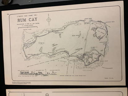
Sold2021Boating maps, rum cay, conception island, San Salvador.Maps from 1981 tropic Isle publishers, Inc By Harry Kline, Rum Cay, Conception island, San Salvador. Size 11“ x 17“See Sold Price
Sold2021Boating maps, crooked island district, little SanMaps from 1981 tropic Isle publishers, Inc By Harry Kline, Crooked island district, little San Salvador little island or little cat island, cat island and little San Salvador. Size 11“ x 17̶See Sold Price
Sold2021Boating maps, the Jumentos Cays end drag at IslandMaps from 1981 tropic Isle publishers, Inc By Harry Kline, The Jumentos Cays in Ragan Island harbour, French wells and turtle sound, crooked Acklins islands. Size 11“ x 17“See Sold Price
Sold2021Boating maps, Spanish wells to Harbor Island, cays toMaps from 1981 tropic Isle publishers, Inc By Harry Kline, Spanish wells to Harbor Island, cays to Eleuthera, current cut and current settlement. Size 11“ x 17“See Sold Price
Sold2018Mallet: San Salvador Island, BahamasMap: I. de Guanahani ou de St. Salvador Cartographer: Mallet Place & Date: Paris / 1683 Size: 3 3/4" x 5 1/2" Condition: wash color; overall age-toning and some browning along edges of margins A charmSee Sold Price
Sold2021Boating maps, Nassau Harbour, New Providence Island,Maps from 1981 tropic Isle publishers, Inc By Harry Kline, Nassau Harbour, new Providence Island, Little Harbor and alder cay anchorages. Size 11“ x 17“See Sold Price
Sold2022Color map of San Francisco Chinatown 1885Heading: -1885 Author: Title: Official Map of Chinatown in San Francisco Place Published: San Francisco Publisher: Date Published: 1885 Description: Color lithographed map. 21.1See Sold Price
Sold2022Faust's Map of San Francisco 1904Heading: -1904 Author: Faust, H.W. Title: Faust's Map of City and County of San Francisco California Place Published: San Francisco Publisher:Published by H.W. Faust Date Published: 1904 <See Sold Price
Sold2022Faust's Map of San Francisco 1898Heading: -1898 Author: Faust, H.W. Title: Faust's Map of City and County of San Francisco California Place Published: San Francisco Publisher:Published by H.W. Faust Date Published: 1898 <See Sold Price
Sold20221852 map of San Francisco from lettersheetHeading: -1852 Author: Quirot & Co. Title: Map of San-Francisco, California. Lith. & Published by Quirot & Co. corner of California & Montgomery Sts. S-Francisco Place Published: San Francisco PublishSee Sold Price
Sold2021Large map of San Mateo County Cal. 1913Heading: (California - San Mateo County) Author: Denny, Edward, & Co. Title: Denny's Pocket Map of San Mateo County, California. Compiled from latest official and private data Place Published: San FraSee Sold Price
Sold2022Color map of San Francisco water districts 1912Heading: -1912 Author: Elliott, G.A. Title: Distributing System for San Francisco, Cal. Spring Valley Water Co. Place Published: San Francisco Publisher:[Spring Valley Water Co. Date Published: <See Sold Price
Sold2022Rare post-earthquake map of San FranciscoHeading: (California - San Francisco) Author: Title: Map of San Francisco, California. Showing limits of the burned area destroyed by the fire of April 18th-21st, 1906, following the earthquake of ApSee Sold Price
Sold2022Map of San Francisco Tidelands for sale, 1869Heading: -1869 Author: Allardt, Geo. F., Surveyor Title: Map No. 3 of Salt Marsh and Tide Lands Situate in the City & County of San Francisco. To be sold at Public Auction, by order of the Boards of TSee Sold Price
Sold2021Andrew F. Bunner O/C, Venice - San Giorgio Maggiore atAndrew Fisher Bunner (New York/Italy, 1841-1897) oil on canvas painting titled "Venice - San Giorgio Maggiore at Sunset," depicting several boats sailing in the lagoons around the island of San GiorgiSee Sold Price
Sold2020HENRY AUGUSTUS FERGUSON (NY, 1842/45 - 1911)"Study from Nature, Venice, 1878", depicting fishing boats at anchor, the Island of San Lazzaro in the distance, oil on academy board, signed and titled verso, with label from exhibition and Italian eSee Sold Price
Sold2017Manuel Baldemor (b. 1947)Kaarawan ni San Isidro Salvador signed and dated 1994 (lower right) Mixed media on canvas 1994 18 x 24" (46 x 61 cm)See Sold Price
Sold2021San Antonio Conservation Society 1926 MapVintage 1926 San Antonio Conservation Society historic guide map of San Antonio de Bexar, drawn by Emily Edwards, portrays San Antonio from 1682-1721, unframed 39 x 28"; Provenance: A Schertz, TX EsSee Sold Price
Sold2022Rare map of Chinatown, San Francisco, 1929Heading: -1929 Author: Wong, J.P. Title: Map of San Francisco Chinatown / ????????: ??? / Meiguo Sanfan Shi hua qiao qu: xiang xi tu Place Published: San Francisco Publisher: Date Published:See Sold Price
Sold2022San Antonio Conservation Society 1926 MapVintage 1926 San Antonio Conservation Society historic guide map of San Antonio de Bexar, drawn by Emily Edwards, portrays San Antonio from 1685-1721, framed, dated 1926 41"h x 30"w Provenance: A SSee Sold Price
Sold20221852 S.F. map with manuscript key to placesHeading: -1852 Author: Quirot & Co. Title: Map of San-Francisco, California. Lith. & Published by Quirot & Co. corner of California & Montgomery Sts. S-Francisco - with added manuscript key Place PublSee Sold Price
Sold2022Color map of S.F. showing water system 1908Heading: -1908 Author: Title: Map of San Francisco showing its uneven territory and the present and proposed main conduits reservoirs and pumping plants of the Spring Valley Water Co. 1908 Place PublSee Sold Price
Sold2022Water distribution in San Francisco 1894Heading: -1894 Author: Spring Valley Water Company Title: Map of San Francisco showing the Water Service of Spring Valley Water Works... Place Published: San Francisco Publisher:Britton & Rey DatSee Sold Price
19 hrs LeftJasper52Southern California Bight islands San Diego LA ADMIRALTY chart 1885 (1955) map$280
1 day LeftSwann Auction Galleries(CITY VIEWS.) Charles Magnus. Group of 16 hand-colored steel engraved bird's-eye views.$600
19 hrs LeftJasper52Rhode Island, part of Connecticut & Massachusetts shewing… LODGE 1780 old map$500
1 day LeftSwann Auction Galleries(RHODE ISLAND.) Henry F. Walling. Map of the State of Rhode Island and Providence Plantations.$500
Jun 28Rail & Road AuctionsThirteen Pieces of Railroad Flatware - Rock Island Lines, Chicago & North Western, Frisco Lines,$50(1 bid)
Jun 23Schilb Antiquarian Rare Books1855 San Francisco 1st ed California Gold Rush Illustrated MAPS Soule Indians$13(4 bids)
1 day LeftSwann Auction Galleries(HONDURAS -- ROATAN ISLAND.) Lieutenant Henry Barnsley; and William H. Toms, engraver. A Draught of$750
Featured19 hrs LeftJasper52The country round Philadelphia. New Jersey Pennsylvania NY. GENTS MAG 1776 map$320
Featured19 hrs LeftJasper52A plan of the operations of the King's army… in New York… FADEN/STEDMAN 1794 map$6,500
Jun 27Rail & Road Auctions19 Railroad and Scenic Postcard Folders - Ogden Route, Feather River, Rock Island, Shasta Route,$50
1 day LeftSwann Auction Galleries(NEW YORK CITY.) Robert A. Welcke; after William Bridges and Peter Maverick. This Map of the City of$375
1 day LeftSwann Auction Galleries(AMERICAS.) John Senex. A New Map of America From the latest Observations.$450


![[Maps & Atlases] Seutter, Matth(ias).: Novus Orbis sive America... (1 of 2)](https://p1.liveauctioneers.com/65/332523/179335174_1_x.jpg?height=282&quality=70&version=1717709447)


