Sold2023Extremité Meridionale de l'Amérique Tierra del Fuego Magellan Str BONNE 1788 map[Cook 2e Voyage] Extremité Meridionale de l'Amérique // Partie Est de la Terre de Feu, le Détroit de Le Maire et partie ouest de la terre des Etats // Canal de Noël // Suite de la CôteSee Sold Price
Sold2020STRAITS of MAGELLAN & TIERRA DEL FUEGO calledTitle: STRAITS of MAGELLAN & TIERRA DEL FUEGO called MAGELLANICA, with Cape Horn Date/Period: 1642-1665 Materials: Copperplate engraved Size: 18 1/4 x 21”. Maps shows the southern most tip of SouthSee Sold Price
Sold2018Bellin: Patagonia / Magellanica / Falkland Islands 1753Carte Reduite de la Partie la plus Meridionale de l'Amerique Bellin's detailed map of the "southernmost part of America"— Patagonia, Tierra del Fuego, and the Falkland, or Malouine, islands, from thSee Sold Price
Sold2022Colored engraving L´AMERIQUE MERIDIONALE. Map of AMERICA, from N. Spain to Tierra del Fuego,Colored engraving L´AMERIQUE MERIDIONALE. Map of AMERICA, from N. Spain to Tierra del Fuego, bordered with 12 cartouches without image. Copper engraving by Baeck, according to Jaillot, for his workSee Sold Price
Sold2022MAP, Tierra del Fuego, BlaeuTierra del Fuego. Willem Blaeu, Tabula Magellanica, qua Tierrae del Fuego, cum Celeberrimis Fretis a F. Magellano et I. Le Maire Detectis Novissima et Accuratissima Descriptio Exhibetur, from TheatrumSee Sold Price
Sold2020Hendrik Hondius Map of Tierra del Fuego and StraiHendrik Hondius (1588-1651) "Freti Magellanici ac novi Freti vulgo Le Maire exactissima delineatio," Amsterdam, ca. 1630. This hand colored map depicts the southern tip of South America, featuring TieSee Sold Price
Sold2020Blaeu Map of Tierra del Fuego or Magellanica 1650Willem Janszoon Blaeu (1571-1638), "Tabvla Magellanica qua Tierrae del fuego, cum beleberrimis fretis a F. Magellano et I. Le Maire detectis novissima et accuratissima descriptio exhibetur," AmsterdamSee Sold Price
Sold2022SOUTH AMERICA. La Plata. Brazil Peru Chile Patagonia Tribes. MALLET 1683 mapTITLE OF THE MAP: 'Païs qui sont aux environs de la riviere de la Plata et du païs des Patagons' (De L'Amerique) The Map runs from Brazil to Tierra del Fuego. DATE PRINTED: 1683 IMAGE SIZE:See Sold Price
Sold2016Monte Sarmiento. Tierra del Fuego. South America. 1856.Print of steel engraving titled „Mont Sarmiento“.Drawn by Gaucherd.Engraved by Lemaitre direxit.From „l‘Univers. Histoire et Description de tous les peuples. Amerique Meridionale, iles diverseSee Sold Price
Sold2016Fuegians. Tierra del Fuego. South America. 1856.Print of steel engraving titled „Fuigiens“.Drawn by Vernier.Engraved by Lemaitre direxit.From „l‘Univers. Histoire et Description de tous les peuples. Amerique Meridionale, iles diverses de l�See Sold Price
Sold2023Print, Herman MollHerman Moll (British, 1654-1732), "A New and Exact Map of the Coast, Countries and Islands within ye Limits of ye South Sea Company, from ye River Aranoca to Tierra del Fuego, and from thence throughSee Sold Price
Sold2023GROUP OF 5 HAND COLORED MAPS OF THE AMERICASGroups of five hand colored antique maps of the Americas, comprising "America Merioio-Nalis (South American)" circa 1620, "Tabula Magellanica Qua Tierre Del Fuego (Strait of Magellan)" circa 1640, "IlSee Sold Price
Sold2018Jansson: Magellan Straits/Tierra del FuegoReserve Reduced! Map Title: Tabula Magellanica Qua Tierrae del Fuego Cartographer: Jansson Place / Date: Amsterdam / 1640 Size: 21 1/4" x 16 3/8" Condition: full color; centerfold repaired and reinforSee Sold Price
Sold2016MARY ANN "TOOTS" ZYNSKY Filet-de-verre vesselMARY ANN "TOOTS" ZYNSKY (b. 1951) Untitled filet-de-verre vessel from the Tierra del Fuego series, the Netherlands, 1980s Signed Z 5 1/2" x 13 1/2" x 12" Provenance: Rago Auctions, Modern, January 201See Sold Price
Sold2019TOOTS ZYNSKY Filet-de-verre vesselTOOTS ZYNSKY (b. 1951) Untitled filet-de-verre vessel from the Tierra del Fuego series, The Netherlands, ca. 1985 Fused and thermoformed glass threads Signed Z 4" x 10 1/2"See Sold Price
Sold2018TOOTS ZYNSKY Glass vesselTOOTS ZYNSKY (b. 1951) Untitled filet-de-verre vessel from the Tierra del Fuego series, The Netherlands, ca. 1985 Fused and thermoformed glass threads Signed Z, museum deaccession number 5" x 9" x 8"See Sold Price
Sold2022c. 1788 French Map of the Eastern United StatesHistoric Maps c. 1788 Map, "Les Etats Unis de L'Amerique Septentrionale, Partie Orientale" (Eastern Part of the Northern United States of America) by M. (Rigobert) Bonne c. 1788 Map titled, "Les EtatsSee Sold Price
Sold20201792 Elwe Map of Southern Portion of Africa -- Carte deTitle/Content of Map: 1792 Elwe Map of Southern Portion of Africa -- Carte de l'Afrique Meridionale ou Pays entre la Ligne & le Cap de Bonne Esperance, et l'Isle de Madagascar Cartographer: J Elwe YeaSee Sold Price
Sold2022Scuola dell'Italia meridionale della fine del XVII secolo Nature morte con composizioni di fiori,coppia di dipinti, olio su tela, W. 64,5 - H. 89 Cm, Expertise Prof. Giorgio FossaluzzaSee Sold Price
Sold2018c. 1650 Map: Mar del Zur Hispanis Mare PacificumHistoric Maps c. 1650 Hand-Colored Map "Mar del Zur Hispanis Mare Pacificum" by Joannes Jansson with California as an Island Earliest Pacific Sea Chart of the to Appear in a Dutch Atlas c. 1650, Hand-See Sold Price
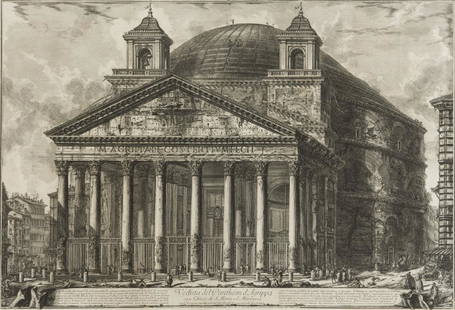
Sold2018Piranesi (Giovanni Battista) Veduta del PantheonPiranesi (Giovanni Battista, 1720-1788) Veduta del Pantheon d'Agrippa, from: Vedute di Roma, etching and engraving, second state (of five) with price erased, an excellent impression, platemark 470 x 6See Sold Price
Sold2017Coronelli: Mare Del Nord Auttore, 1690Map: Mare Del Nord Auttore IL PM Coronelli … Il Sig Giovanni Grimaldi Savio di Terra Ferma Maker: Coronelli, Vincenzo Date: 1690 Medium: Copperplate engraving Description: An outstanding map by oneSee Sold Price
Sold2022OVIEDO Y VALDES, GONZALO FERNANDEZ DE Historia General y Natural de las Indias, Islas y Tierra FirmaOVIEDO Y VALDES, GONZALO FERNANDEZ DE Historia General y Natural de las Indias, Islas y Tierra Firma del Mar Oceano. Madrid: Real Academia de la Historia, 1851-55. Three volumes in four. The first comSee Sold Price
Sold2020"Il Mappamondo" World twin hemispheres CookTITLE/CONTENT OF MAP: 'Il Mappamondo o sia Descrizione Generale del Globo ' A decorative map of the world in twin hemispheres, showing the voyages of Cook and Bougainville between 1766-1771. The easteSee Sold Price
6 days LeftDuMouchellesRigobert Bonne (French, 1727-1794) Hand Colored Engraving Ca. 18th Century, Les Etats Unis De$50(1 bid)
5 days LeftSwann Auction Galleries(VUES d'OPTIQUE.) Group of 15 hand-colored engraved European vues.$300
Jul 06Case Antiques, Inc. Auctions & Appraisals2 Goya Etchings from Los Proverbios, Lluivia de Toros & Una Reina del Circo$500
5 days LeftBertolami Fine Art s.r.l.FILIPPO DE PISIS (Ferrara 1896-Brugherio 1956) Cocò alla finestra€12,000


![Extremité Meridionale de l'Amérique Tierra del Fuego Magellan Str BONNE 1788 map: [Cook 2e Voyage] Extremité Meridionale de l'Amérique // Partie Est de la Terre de Feu, le Détroit de Le Maire et partie ouest de la terre des Etats // Canal de Noël // Suite de la Côte](https://p1.liveauctioneers.com/5584/294908/156576945_1_x.jpg?height=310&quality=70&version=1688565030)